
News Summary
Residents in Lexington, Kentucky are urged to prepare for severe weather as tornadoes and flash floods are projected over the next few days. With damaging winds and potential rainfall of up to 15 inches, officials are advising everyone to stay informed and have emergency kits ready. The greatest risks will occur late Wednesday into Thursday and additional storms are expected through the weekend. Residents are reminded to seek shelter and avoid unnecessary travel during these hazardous conditions.
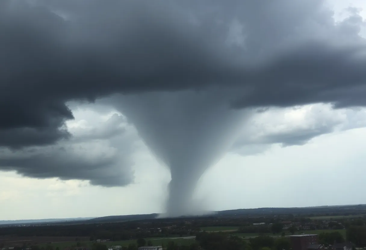
Weather Alert: Tornadoes and Flash Floods Headed for Lexington, Kentucky!
Attention residents of Lexington! Buckle up as we brace ourselves for some seriously wild weather over the next four days. Starting late on Wednesday, April 2, forecasters are predicting a cocktail of trouble in the form of hail, tornadoes, and damaging winds. Reports say these storms could be particularly robust, leaving us all gripping our chairs a bit tighter.
Be Prepared for Severe Weather
As the skies begin to darken, it’s advisable for everyone to start planning ahead. If the wind picks up and the storms roll in, individuals are urged to seek shelter immediately. Make sure to stay away from those doors and windows, and don’t forget to turn on your emergency alert systems—better safe than sorry! Safety truly is our top priority right now, especially with the governor expressing concern for everyone’s well-being during potential overnight storms, which can often be the most dangerous.
Flash Floods and Tornado Risks
Western Kentucky, in particular, is shining in the spotlight for severe weather risks. The National Weather Service has flagged this region for possible “\(b>life-threatening\)” flash floods, especially on Thursday, April 3. They’re predicting rainfall that could reach a whopping 15 inches in some areas, which significantly ramps up the flood risks. Meanwhile, the possibility of tornadoes, with potential ratings up to EF-5 (the highest level), is definitely not something to ignore.
Tracking the Storm’s Path
As the storm system is expected to sweep through, the timeline looks like this: the farthest regions of Western Kentucky may start to feel the impact around 6 p.m. on Wednesday, while Central Kentucky, including Lexington, could see the worst between midnight and 4 a.m. Those in Eastern Kentucky should remain alert from 4 a.m. to 8 a.m. as the storms roll through. It’s a race against time, and everyone needs to stay on top of the weather updates.
Driving Cautions
Travelers, take heed! Check road conditions before hitting the road by visiting state traffic resources. With storm systems bringing damaging winds (gusts up to 50 mph), it’s critical to stay informed about safe routes. One simple rule: don’t travel unless absolutely necessary during severe weather occurrences.
Keeping an Eye on the Situation
Lexington is in an enhanced risk zone for severe thunderstorms, so keep those eyes peeled! Following the storms on Wednesday, additional severe weather is still on the horizon for Thursday, Friday, and even Saturday, though the risk on these days is slightly lower.
Many counties in the storm’s path are not just dealing with wind advisories; residents will need to be cautious well into Thursday morning. Make sure your emergency kits are stocked and that roofs are inspected for any pre-existing damage. Preparation can really save lives when the weather gets rough!
Unusual Weather Patterns
The National Weather Service flags this developing situation as an unusual combination of tornado and flood risks, particularly for this time of year. This isn’t just your average spring storm—forecasters mention it could be a once-in-10-to-15-year occurrence for our lovely region. So, Lexington residents, it’s time to heed warnings, prepare for the worst, and find comfort in knowing we’re all in this together.
With the right precautions, we can weather the storm—both literally and figuratively. Stay alert, stay safe, and let’s all keep each other informed as the skies darken more and more.
Deeper Dive: News & Info About This Topic
HERE Resources
Severe Tornado Outbreak Creates Chaos Across the South and Midwest
Yemassee Residents in a Monkey Chase: 24 of 43 Escapees Recovered!
South Carolina Emerges as U-Haul’s Top Growth State in 2024
Tragic Incident in Greenville: Young Woman Shot by Deputies
Charleston Residents Concerned About Rapid Growth and Infrastructure Strain
Columbia City Council Revises Building Height Regulations
Severe Thunderstorms Expected in Columbia, SC on March 31
Sunny Skies Ahead for CSRA After Recent Storms
Deadly Storm System Devastates Midwest and Southeast
Silver Fire Expands Near Bishop, California, Leading to Evacuations
Additional Resources
- WKYT: First Alert Weather Day
- Wikipedia: Tornado
- KY Kernel: Severe Weather in Lexington
- Google Search: Severe Weather Lexington
- WLKY: Severe Alert for Strong Storms
- Encyclopedia Britannica: Flood
- Kentucky.com: Weather News
- Google News: Kentucky Weather Alert